• Skip to primary navigation
  • Skip to main content

Powdermill Nature Reserve

Maps and Geographic Information Systems

Logo Carnegie Museum of Natural History

  • Home
  • About
  • Maps
  • Projects
    • Motus Terra – The Motus Station Viewshed Planning Tool
    • Pennsylvania Unconventional Natural Gas Wells
    • Unmanned Aerial Vehicle (UAV)
    • Powdermill Vegetation Survey
    • Historic Aerial Imagery
    • Childs Frick Abyssinia Expedition
    • Powdermill Nature Reserve Recreation Maps
  • Recent Posts

Web Map

GIS Lab Produces Childs Frick Abyssinia Expedition Web Map

March 18, 2015 by James Whitacre

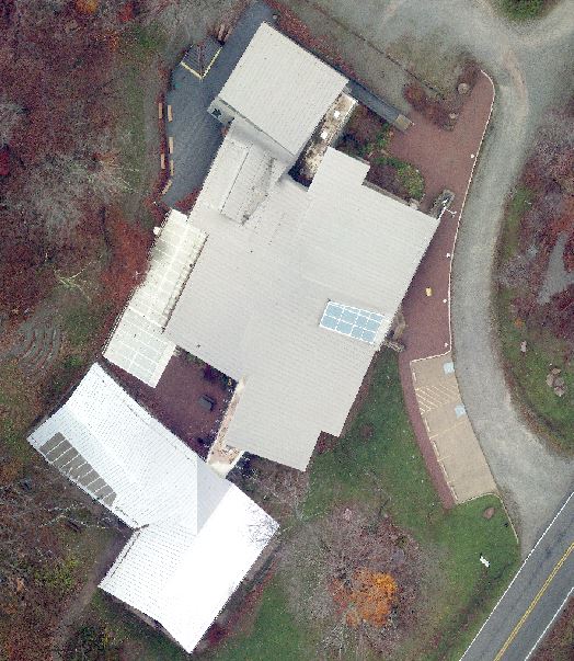
In collaboration with the CMNH Section of two explorers on the 1911-1912 expedition
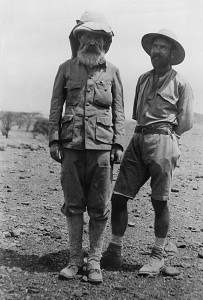
Mammals, the GIS Lab has produced a web map documenting the route and highlights of the 1911-1912 Childs Frick Abyssinian Expedition. Childs Frick is the son of renowened Pittsbugh industrialst Henry Clay Frick.  Over 500 mammals were collected for the Carnegie Museum during the expedition.

Click here to get more information on the expedition, as well as to see the web map.

Filed Under: Web Map

Additional report data now available through unconventional wells map viewer

March 18, 2015 by James Whitacre

You can now access records from seven DEP oil & gas reports Screenshot showing the related records button at the bottom of the recordthrough the GIS Lab’s unconventional wells map viewer. All records from the permits issued, SPUD, PUC, waste, compliance, production, and well formation reports are now available for each well in the map.  To access these records, click on a well of interest.  In the well pop up, click “Show Related Records” to access a table of records specific to that well.

Filed Under: Web Map

GIS Lab Releases Web App Highlighting Forest Ecology Research at Powdermill.

January 26, 2015 by James Whitacre

The CMNH GIS Lab has released a web app Screenshot of the homepage of the new web apphighlighting recent forest ecology research initiatives at Powdermill Nature Reserve following a unique research opportunity, a large wind storm in June 2012.  The project aims to test the long-term effects of salvage logging and deer exclusion on forest regeneration and wildlife following a major disturbance.  The application combines maps, photos, and some background text to acquaint users with the project.

Click here to see the web app!

Filed Under: Web Map

UAV Imagery Added to Powdermill Nature Reserve Map

November 3, 2014 by James Whitacre

In collaboration with Civic Mapper, the Powdermill GIS Lab has captured fine-scale aerial imagery across various part of Powdermill Nature Reserve using an unmanned aerial vehicle (UAV).  Imagery from two locations, the nature center and the avian research center, have been added as an optional layer to the Powdermill Nature Reserve web map.  (Note: for best results turn off the Powdermill Nature Reserve boundary layer). The imagery was captured on October 29th and 31st using a Go Pro camera on a DJI Phantom 2 flying at 40 meters. If you would like either of the full mosaic images (with or without georeferencing), please contact the GIS Lab.drone image of Powdermill Nature Center from above

Filed Under: Data, Web Map

GIS Lab Releases New Pennsylvania Unconventional Wells Map Viewer

October 16, 2014 by James Whitacre

The Carnegie Museum of Natural History GIS Lab has produced a new web map viewer that adds screenshot of software showing a map of Pennsylvania and its gas well locations
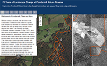
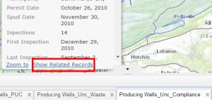
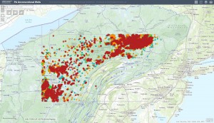
additional functionality. Users can now graph unconventional gas production, violations, or data errors either state-wide or over a user-defined area by clicking the “Chart” button. The new “Draw” button allows the user to add graphics and text in order to produce their own maps. Like the previous web map, users can click on any well to view information in permits, drilling, inspections, violations, and other information. Users can still also can click on any producing well to see a graph of gas production since mid-2009 for that specific well. Stay tuned for an additional forthcoming update that will give users the ability to access a table of information on wells by stage, which can be filtered by map extent and exported as a CSV.

Click here to view the new web map.

Filed Under: Web Map

New Historic Aerial Imagery Web Map

July 17, 2014 by James Whitacre

The CMNH GIS Lab has produced a new web map to allow users to explore HistImagerychanges in the Powdermill landscape from 1939 to present using historic and current aerial imagery.  The new map includes a list of bookmarks highlighting some of the sections of the reserve which have undergone substantial change.  Photos for this map were obtained from Penn State’s Penn Pilot Program.  While the map utilizes 1939 imagery, the GIS Lab has georeferenced and mosaiced all available imagery from the Penn Pilot for the Ligonier Valley.  These rasters are available upon request by contacting the GIS Lab.

Filed Under: Web Map Tagged With: 1939, Historic Imagery, Powdermill Nature Reserve

  • « Go to Previous Page
  • Go to page 1
  • Go to page 2
  • Go to page 3
  • Go to page 4
  • Go to page 5
  • Go to Next Page »
One of the Four Carnegie Museums of Pittsburgh | ©2023 Carnegie Institute | Privacy Policy | Terms of Use | Accessibility
Get eNews

Our eNews features information on exhibitions, upcoming events, and subscriber-only special offers!