Through popular mapping applications such as google maps and bing maps, aerial imagery has become an integral part of how we view our world. However, aerial imagery has been collected for more than 150 years! The first aerial imagery was captured from a hot air baloon in 1858. In southwestern Pennsylvania, the earliest available imagery was captured in June 1939.
The GIS Lab at Powdermill Nature Reserve has collected, georeferenced, and mosaiced historic aerial imagery for the Ligonier Valley from 1939 to the present. In addition to being an interesting reference, historic aerial imagery is a powerful tool for ecological research. Scientists at Powdermill have utilized this collection of imagery to identify forest stands of various ages and land use histories to determine how human impact shapes forest composition. These rasters are available upon request by contacting the GIS Lab.
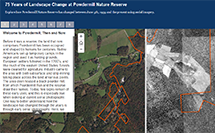
Seventy-five years of landscape change at Powdermill Nature Reserve is a new app produced by the GIS Lab that offers a guided tour comparing 1939 imagery to what can currently be found on the reserve. This app includes several bookmarks highlighting interesting locations around the reserve.