You can now access records from seven DEP oil & gas reports 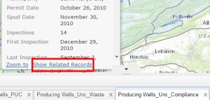 through the GIS Lab’s unconventional wells map viewer. All records from the permits issued, SPUD, PUC, waste, compliance, production, and well formation reports are now available for each well in the map. To access these records, click on a well of interest. In the well pop up, click “Show Related Records” to access a table of records specific to that well.
Maps and Geographic Information Systems
![]()