ArcGIS Version 2.9:
Motus Terra
(user guide can be found in Documents folder)
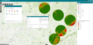
Motus Terra is an ArcGIS Pro project built around Python script tools to help optimize the planning and installation of Motus stations. Motus Wildlife Tracking System researchers can utilize Motus Terra to plan, manage, and update their Motus station data within ArcGIS Online and ArcGIS Pro.
Motus Terra contains two custom Python script tools. The Motus Publish to ArcGIS Online script tool creates and publishes the Motus Stations and Motus Visible Areas feature classes to ArcGIS Online. The Motus Viewshed To Contours tool performs data management on the feature classes as well calculates the height needed for a nanotag to ascend into the viewshed of a station within a 15 kilometer radius.
Getting Started with Motus Terra:
Editing in ArcGIS Online:
Operating Requirements
Motus Terra was packaged using ArcGIS Pro Version 2.9. Before running the tool ensure that the following extensions are activated: 3D Analyst and Spatial Analyst. This tool also requires a higher processing capability than most standard machines offer. The critical component for any machine to execute this tool properly is a GPU with a CUDA compute capability of 3.0 or higher (https://developer.nvidia.com/cuda-gpus). Motus Terra utilizes data storage services of ArcGIS Online, therefore, users of Motus Terra will be required to have an ArcGIS Online account capable of storing feature services. Motus Terra has been programmed to be utilized by Motus sites located within the United States or Canada only. Sites outside these two countries will require additional programming or modifications.