During the summers of 2006, 2007, and 2008, Powdermill Nature Reserve completed an extensive vegetation survey. These data will serve as an ecological archive and baseline data, enabling staff to track spatial and temporal vegetation changes on the reserve. Additionally, these data have been used to create vegetation maps, enhance research, and serve as permanent plots for outside researchers.
- View the results of the vegetation survey.
- View the vegetation atlas of the 20 most abundant tree species.
- Download the Powdermill Nature Reserve vegetation dataset and protocol.
- Download the data collection protocol.
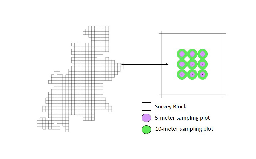
Powdermill staff have placed a permanent grid across the entire reserve (see image below). Each 120 meter x 120 meter square within the grid represents a sampling block. Sampling blocks are permanently marked with a rebar stake at the center point. Nine plots were established at the center of each block in a 3×3 square. Trees (>8 cm DBH) were sampled within a 10 m radius of each plot center, and all other vegetation was sampled within a 5 m radius. Across the reserve, there are more than 500 sampled blocks totaling 4,525 vegetation plots. For a more detailed explanation of the sampling scheme, please see the data collection protocol.