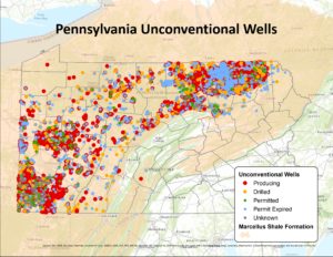
The latest version of the Carnegie Museum of Natural History Pennsylvania Unconventional Natural Gas Wells data set is now available. The update includes all well records through the end of March 2017, as well as production and waste through February 2017. As with previous versions of the data set, you can now Download the data without registering. For information about updates, see the Version Information page. For more information about the dataset, please see the Metadata and User License Agreement. You can also view the data without GIS software through our webmap.
Pennsylvania Unconventional Natural Gas Wells 2016 Q4 Update
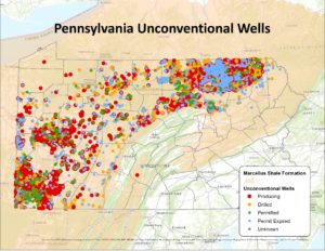
The latest version of the Carnegie Museum of Natural History Pennsylvania Unconventional Natural Gas Wells data set is now available. The update includes all well records through the end of 2016. As with previous versions of the data set, you can now Download the data without registering. For information about updates, see the Version Information page. For more information about the dataset, please see the Metadata and User License Agreement. Please also check out our webmap, in which we soon plan to add a time slider to view well history through 2000 in six-month intervals.
Expanding Powdermill’s bird banding program with post-release tracking.
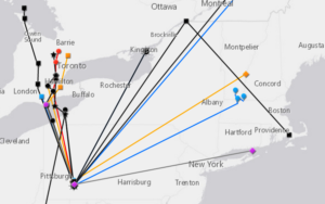
In order to conserve animals, we need to know what habitats they are using throughout their lives. While Powdermill’s more than 50-year-old bird banding program has taught us a lot about how bird populations have changed over time, we know comparatively little about where these birds go after they leave Powdermill. Traditional mark-recapture methods, such as bird-banding, result in less than 1 in 1000 birds being re-detected at another location. However, technological advances now permit radio frequency nano-tags, about the size of a black bean, to be attached to even small-bodied species. These tags emit a coded signal that identifies the individual and can be tracked on the ground or be detected by any automated sensor when an individual animal comes within range. When attached to large antennae placed at least 40 feet high, these sensors can detect wildlife within a ~9-mile radius. We deployed 47 nano-tags on five species this past spring at PNR. With 17 tags redetected (36%), this methods proved to be more than 350 times more effective at tracking the movement of species than traditional mark-recapture methods. Click here to see the full, interactive map of redetected tags.
GIS Lab Presents Unmanned Aerial Vehicle (UAV) Research at National Conference
The Carnegie Museum of Natural History GIS Lab has recently 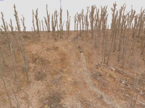 presented research on forest ecology at the American Geophysical Union Fall Meeting in San Francisco. The lab has been using unmanned aerial vehicles (UAVs) to conduct efficient surveys of tornado blowdowns on the reserve. Hundreds of aerial photographs are stitched together to form a 3-dimensional model using a process called photogrammetry. The lab has developed a set of tools that use these 3D models to automatically identify tree locations, measure tree-level structural information, and estimate biomass. This poster explains the logic behind each of the tools, and explains the preliminary results of this work.
Stay tuned for further updates.
Download a PDF poster or view one of the mentioned 3D models.
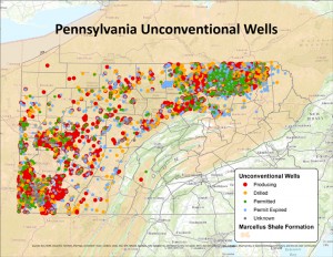
Pennsylvania Unconventional Natural Gas Wells 2016 Q3 Update
The latest version of the Carnegie Museum of Natural History Pennsylvania Unconventional Natural Gas Wells data set is now available. The update includes all well records through September 30, 2016 and production through July 2016. As with previous versions of the data set, you can now Download the data without registering. For information about updates, see the Version Information page. For more information about the dataset, please see the Metadata and User License Agreement. Please also check out our webmap.
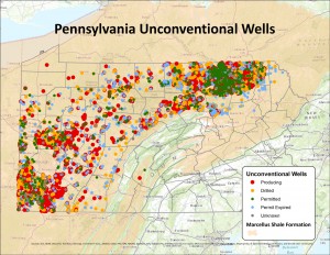
Pennsylvania Unconventional Natural Gas Wells 2016 Q2 Update
The latest version of the Carnegie Museum of Natural History 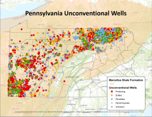 Pennsylvania Unconventional Natural Gas Wells data set is now available. The update includes all well records through June 30, 2016. As with previous versions of the data set, you can now Download the data without registering. For information about updates, see the Version Information page. For more information about the dataset, please see the Metadata and User License Agreement. Please also check out our webmap, as well as PA DEP’s recently launched interactive map available on their oil and gas reporting site. As we are currently experiencing an issue with our FTP site, please request a copy by email (GIS [at] carnegiemnh.org).
Pennsylvania Unconventional Natural Gas Wells 2016 Q1 Update
The latest version of the Carnegie Museum of Natural History Pennsylvania Unconventional Natural Gas Wells data set is now available. The update includes all well records through March 31, 2016 as well as production and waste through January 2016.. As with previous versions of the data set, you can now Download the data without registering. For information about updates, see the Version Information page. For more information about the dataset, please see the Metadata and User License Agreement. Please also check out our webmap, as well as PA DEP’s recently launched interactive map available on their oil and gas reporting site.
Pennsylvania Unconventional Natural Gas Wells 2015 Q4 Update
The latest version of the Carnegie Museum of Natural History 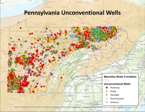 Pennsylvania Unconventional Natural Gas Wells data set is now available. The update includes all well records through the end of 2015. As with previous versions of the data set, you can now Download the data without registering. For information about updates, see the Version Information page. For more information about the dataset, please see the Metadata and User License Agreement. Please also check out our webmap, as well as PA DEP’s recently launched interactive map available on their oil and gas reporting site.
Pennsylvania Unconventional Natural Gas Wells 2015 Q3 Update
The latest version of the Carnegie Museum of Natural History Pennsylvania Unconventional Natural Gas Wells data set is now available. The update includes all well records through September 30, 2015 as well as production and waste figures through July, 2015. As with previous versions of the data set, you can now download the data without registering. For information about updates, see the Version Information page. For more information about the dataset, please see the Metadata and User License Agreement.
Pennsylvania Unconventional Natural Gas Wells 2015 Q2 Update
The latest version of the Carnegie Museum of Natural History Pennsylvania Unconventional Natural Gas Wells data set is now available. The update includes all through June, 2015. Note: please see the accompanying metadata for information on minor changes to production and waste reporting corresponding to PA DEP now releasing monthly production and waste reports. As with previous versions of the data set, you can now Download the data without registering. For information about updates, see the Version Information page. For more information about the dataset, please see the Metadata and User License Agreement.