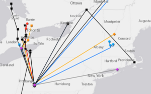
In order to conserve animals, we need to know what habitats they are using throughout their lives. While Powdermill’s more than 50-year-old bird banding program has taught us a lot about how bird populations have changed over time, we know comparatively little about where these birds go after they leave Powdermill. Traditional mark-recapture methods, such as bird-banding, result in less than 1 in 1000 birds being re-detected at another location. However, technological advances now permit radio frequency nano-tags, about the size of a black bean, to be attached to even small-bodied species. These tags emit a coded signal that identifies the individual and can be tracked on the ground or be detected by any automated sensor when an individual animal comes within range. When attached to large antennae placed at least 40 feet high, these sensors can detect wildlife within a ~9-mile radius. We deployed 47 nano-tags on five species this past spring at PNR. With 17 tags redetected (36%), this methods proved to be more than 350 times more effective at tracking the movement of species than traditional mark-recapture methods. Click here to see the full, interactive map of redetected tags.