The CMNH GIS Lab has produced a new web map to allow users to explore 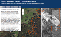 changes in the Powdermill landscape from 1939 to present using historic and current aerial imagery. The new map includes a list of bookmarks highlighting some of the sections of the reserve which have undergone substantial change. Photos for this map were obtained from Penn State’s Penn Pilot Program. While the map utilizes 1939 imagery, the GIS Lab has georeferenced and mosaiced all available imagery from the Penn Pilot for the Ligonier Valley. These rasters are available upon request by contacting the GIS Lab.
Maps and Geographic Information Systems
![]()
One of the Four Carnegie Museums of Pittsburgh | ©2023 Carnegie Institute | Privacy Policy | Terms of Use | Accessibility
Get eNews
Our eNews features information on exhibitions, upcoming events, and subscriber-only special offers!