Here at Powdermill Nature Reserve, the Carnegie Museum of Natural History’s environmental research center, we were reminded of the ever-present forces of nature when a flood recently inundated the Ligonier Valley. Homes and buildings were damaged and numerous people had to be rescued by swift water rescue crews. At Powdermill, a few of our buildings also experienced damage (see the video below).
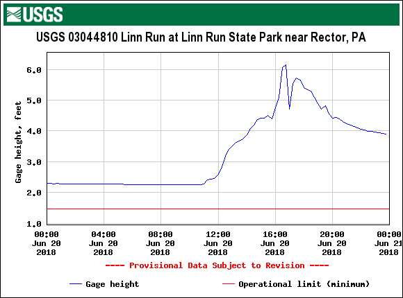
On June 20, 2018, over 5.5 inches of rain fell on Powdermill and the surrounding area in about 6 hours. At the nearest USGS stream gauge at Linn Run State Park, the water level rose about four feet in five hours. The force of the flood waters was able to move large boulders, take down trees, and change the course of many streams, including Powdermill Run. The flood levels were so high that we have reason to believe that this was a very significant flood event. But was it a ‘100-year flood’?
The concept of the ‘100-year flood’ is quite familiar, but this concept is a bit misleading. It does not mean that a flood rated as a ‘100-year flood’ will occur every 100 years. Rather, it means that every year, there is a 1% chance that a flood will reach the annual exceedance probability (AEP) (i.e. the height of the flood waters in a particular area). On average, a flood will reach the AEP level every 100 years. This definition was established for the National Flood Insurance Program. For more information, see the USGS page The 100-Year Flood—It’s All About Chance.
So the question still stands, was the flood at Powdermill a ‘100-year flood’? Using the power of maps and GPS, the GIS lab at Powdermill decided to compare the FEMA flood zone maps to the flood levels observed in the field. As the map shows, it appears that it is very close, though more assessment is needed to be certain.
While the damage was extensive, this event will provide researchers at Powdermill the opportunity to study yet another instance of how natural disasters affect the ecology and landscape of the nature reserve. A similar event six years ago, in June 2012, occurred when a tornado touched down in the Ligonier Valley and blew down nearly 50 acres of forest in the nature reserve. Powdermill continues to utilize these areas in numerous on-going research projects to track succession and plant-animal interactions after a disturbance. While the flood event may not produce an obvious research project at the moment, Powdermill researchers will be keeping their eyes open to see how we may need to respond.