The Carnegie Museum of Natural History GIS Lab has recently 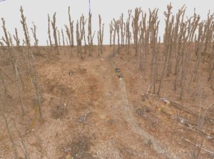 presented research on forest ecology at the American Geophysical Union Fall Meeting in San Francisco. The lab has been using unmanned aerial vehicles (UAVs) to conduct efficient surveys of tornado blowdowns on the reserve. Hundreds of aerial photographs are stitched together to form a 3-dimensional model using a process called photogrammetry. The lab has developed a set of tools that use these 3D models to automatically identify tree locations, measure tree-level structural information, and estimate biomass. This poster explains the logic behind each of the tools, and explains the preliminary results of this work.
Stay tuned for further updates.
Download a PDF poster or view one of the mentioned 3D models.